Wednesday, December 5, 2012

Devil's Bathtub


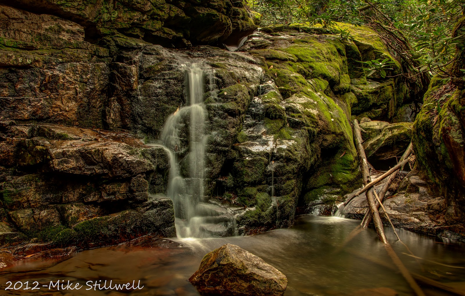
Three weekends ago we were stymied by high water in our attempt to make a return trip to the Devil's Bathtub in Scott County, Va. This time we made it, barely ... I've been around creeks my entire life and - with God as my witness - I've never stepped on rocks that were as slick as those in that creek. I'm not sure what happened to them but it was dang near impossible to step on any of them and not slip. I can understand the rocks in the water and even the ones that were wet with dew being slick, but even the dry rocks had a slime on them.

We stumbled and bumbled and waded through the 13 creek crossings along the near 2 mile hike to get to the Bathtub. Once you get there you know it was worth the effort, there's no other place around here that I know of that looks like this series of pools and cascades. The water is as perfectly clear as you'll ever find; the rocks on the bottom of the pools are a blue-gray color, and there's impossibly green algae that gives the pools a teal color that, when you first see it, you'll be sure that it's fake.

There was a lot more water flowing this time than at any other time I've been here, so the pools were deep and the cascades into the pools were rolling. We're guessing the pool is more than 10 feet deep.

pool below the Bathtub
The trail at this point climbs a steep bank covered in - you guessed it - slime covered rocks. I climbed the bank, followed the creek to a point above the bathtub, and when I looked down and saw the whole creek bottom covered in green algae I just knew it would be too slick to walk down the creek to the get to where we could take some good pictures. But when I got in the creek I found that I could walk on the algae and get a reasonable amount of traction. We guess this pool is more than 10 feet deep.


the Bathtub


-----------------------------------------------------------------------------
Directions: Take US Hwy. 23/US Hwy. 58/US Hwy. 421 toward Gate City. In Gate City, continue going straight as the road becomes East Jackson Street and, ultimately, VA Route 71. Head east on Route 71 for a little over a mile. From here, take VA Route 72 to the left toward Fort Blackmore. Shortly after VA Route 65 and VA Route 72 merge, turn left onto VA Route 619 (Old Stoney Creek Road).

Once on Route 619/653 for about 3 1/2 miles, the road splits, follow 619 to the right, travel about 1 mile more and look for the Devils Fork sign. Route 619 takes a sharp left and becomes Forest Road 619 (there is no street sign). Travel over the one-lane bridge and turn left just before the abandoned white house with a chain link fence. Follow this unmarked dirt road to the end, where you will find parking for the trail. The road to the parking lot is very rutted and may not be accessible by all vehicles, high clearance and 4wd is recommended. You cannot park along the road and walk because the property on both sides of the road is posted, you must get to the parking area at the end of the road.

The trail starts at the top of the wooden stairs (yep, stairs) at the parking area. It proceeds downhill about 1/4 mile to the first of 13 creek crossings. A hundred or so feet past the first creek crossing, the trail splits - there are several trees with yellow blazes here - you want to take the trail going left. After 50 ft the trail will split - start looking to the right for the yellow blazes to pick up the trail  From here the trail generally follows the creek, crisscrossing it 12 more times over the the next 1 1/2 miles.

Tuesday, November 6, 2012

Falls of Little Stony Creek

The forecast was for clouds with a 50% chance of rain, but as we've all come to expect, weather forecasting in the mountains of NETN/SWVA is not an exact science. The trip was supposed to be a return to the Devil's Bathtub is Scott Co. Va with an excursion to Little Stony if time and energy permitted. 

We arrived at the first of the 13 creek crossings required to get to the bathtub and was greeted by high water, too high to make a safe crossing, obviously the runoff from the previous week's snow. So on to plan B.

We navigated through the mountains of Scott county to the Hanging Rock Rec. Area, then on to the trailhead for the Falls of Little Stony creek. The runoff that prevented us from getting to the bathtub made for a nice volume of water flowing over the falls.

This first picture is of a long cascade at the top of the Upper Falls, which is less than 1/4 mile from the parking area.
Cascade at the top of the Upper Falls
This next picture is of the Upper Little Stony Falls, a 28 vertical waterfall that lands in a large pool that is about 10 feet deep. Stone steps lead down to the base of the falls.

Upper Little Stony Falls
Back on the we traveled another 1/4 mile to the next bridge over the Middle Little Stony Falls, which is about 10 ft. high. There no plunge pool to speak of, just a long cascade that continues into a gorge. We had the scramble down the bank to get to the creek. This next picture was taken about 100 ft downstream from the falls.

Middle Little Stony Falls and the downstream cascade
This next picture is an isolation of a single limb at the base of the Middle falls. Trying to time the picture when the leaf wasn't blowing around took several attempts.

Lonely Leaf at Middle Falls

Just a few hundred yards further down the trail is Lower Little Stony Falls. It is the biggest of the three falls. This 40 footer is pretty spectacular looking; it's really wide with a large shallow plunge pool. The view from the wooden platform was just barely ok; the best looking water was the cascade downstream, but the "trail" to the base of the falls was very steep, and wet, and slick, with leaf-covered rocks, and mud. I first tried going downstream to try and find a way down to a large rock that jutted out into the creek, but no joy. So we slid/stumbled down the bank to the base and got the best shots of the falls from down there.

Lower Little Stony Falls and downstream cascade
All in all it was a good day. The trail was in pretty good shape, only a little slick in a few places. There were stone and wooden steps in the steeper areas, I'd rate the trail itself from easy to moderate in difficulty.


-------------------------------------------------------------------------------------

To reach the Little Stony Falls trailhead from Dungannon, follow Route 72 north for 7.7 miles, then turn left onto Retford Rd (Route 664.) After 0.4 miles, take a slight left at Corder Town Rd. Follow Corder Town Rd. for 0.8 miles, then turn left onto Forest Road 700. Follow Forest Road 700. for 1.3 miles, then take a slight left onto Route 701. The trailhead is at the end of the road.

Sunday, October 21, 2012

First Attempt at Timelapse

Ever since I decided that I wanted to do a timelapse video I've had the weir dam below South Holston dam in my head as a prime video target. There's a predictable scenery change in a relatively short time frame.

I finally talked myself into buying the Triggertrap app for my iPhone and the cable required for my D90. All I needed to do was be at the weir dam when I knew that TVA would be generating. I got half of that this past Saturday afternoon when I took my youngest and went without knowing the generation schedule ... realistically to scout out a good place to take the pictures, and to practice using the Triggertrap app to do the work.

I found a nice place with a reasonable background and ran off 100 exposures. I used Lightroom v4 to do the post-processing and video generation work.  Even though there wasn't any water over the weir it was a decent run, the clouds were really rolling. Here's those 100 exposures rolled into a 5 second video:

I checked the Sunday generation schedule, saw that it was set for 1PM through 2PM Sunday, and made plans to come back in time to record a full cycle. The only bad thing was the bluebird skies, it would have been really nice if Saturday's clouds were around on Sunday, but no such luck. I had to find a different spot than Saturday else I'd be shooting into the sun. I got setup in my new spot just as the generation warning horn went off ... excellent!

What follows is 250 exposures, taken at 15 second intervals, over 50 minutes. The full video is about 25mb, which is too big to be interwebs friendly. So I ran it through Windows Movie Maker and saved it as 'Youtube' which made it about 10mb. The sky gets a bit pixelated but it's a reasonable tradeoff.


The Hunt for Swirls

"Swirls" are long exposure pictures of flotsam or leaves that are floating around in eddies in streams. The long exposure makes the swirling trails. I'm not sure what it is about swirls that I find so interesting but ever since I saw the first picture of one I've kept an eye out for them on every waterfall hike.

The past two weekend hikes were really big fun, one to Laurel Falls (via the trail off 321) and a second trip back to Big Creek to see the Midnight Hole in fall colors. Both hikes produced some excellent swirly opportunities, it's was just unfortunate that the weather wasn't real good for getting good pictures.

These next two picture are from the Laurel Falls Hike on 10/14/2012. I've walked in to Laurel Falls several times from the Dennis Cove side, but never from the 321 side. The trail is part of the AT which makes me a section hiker now. On the first 1/2 of the trip the trail generally follows the river; the second half of the trip goes uphill to the top of a ridge then slowly wanders back down to the river about 1/4 short of the falls. It was a beautiful cloudless day, which meant that good waterfall pictures would be tough to get. So my goal for the day was to get some good swirl pictures. The next two pictures were taken with just a polarizer; it wasn't enough to knock down the sky, but it was enough to get a 10 second exposures to capture the swirl.


The next four pictures were taken on a my second trip to the Big Creek area of the GSMNP on 10/18/2012. I was there about 5 weeks ago when it still green and the water was way low. This time the colors were fantastic, lots of yellows and limes, plenty of orange and red, and just enough dark green to set it all off. If it wasn't peak color day, it had to be close. The only downside was the cloudless sky that made it tough to get good water pictures ... it was a polarizer + ND filter day.

While waiting on the rest of our group to arrive, I took this picture of the bridge to the Baxter Creek trail. It had a decent leaf swirl going but I didn't have the ND filter installed so I couldn't get an exposure longer than 15 seconds ...

Bridge to Baxter Creek Trail with a swirly
I found a video on the interwebs that said the "largest undocumented chimney in the Park" was located just off the Baxter Creek trail, so that's where we went first. The lighting was not optimal and most of the leaves were already down, but I took some pictures anyway. The chimney is probably 30 feet tall.
Chimney on Baxter Creek Trail
We went back through the parking area and got on the trail to the Midnight Hole. The next picture was taken from a rock in the middle of the creek on the way, and yes, it really was that yellow looking up the creek, it was stunning. If this wasn't the peak color day for this part of the park it was darn close.

Looking upstream toward Midnight Hole
Water flow into the Midnight Hole was much better than the last time we were here. And the breeze was blowing just enough to fill the creek with leaves ... excellent! There were leaves swirling at every depth in the pool it was stunning to look at. Every once in a while a cloud would pass over that would knock the sun down for a few seconds. I tried to get some long exposures that showed the swirling leaves but it was tough. This next picture is one of the best.

Midnight Hole Leaf Swirly
The next day the park was inundated with dust that blew in from Oklahoma, covering the whole place with a dark dusty fog that would have made picture taking next to impossible ... we definitely hit it on the right day.

Sunday, October 7, 2012

Blustery Day at Rough Ridge

All week long a trip was planned to hit the BRP at first light on Sunday morning, but, as is typical with the weather around here, it all changed in a matter of hours. So an audible was called Friday night and we hit the road Saturday morning instead. I picked up my compadres at 6:30 in Minneapolis NC and made it to the Rough Ridge parking lot just before sunrise ... excellent. The day's plan included pictures from Rough Ridge, the classic Linn Cove viaduct pose, and pictures of an arched footbridge we had seen on the interwebs that is on the trail at the overlook.

It was windy ... dang windy ... no, it was 'blow us off the mountain' windy.

We made it up the trail to the boardwalk just as the sun was peeking over the horizon. The wind was trying to blow us off the boardwalk, but we hung around with a few other hardy folk and snapped several brackets of the sunrise over the valley to the south and east.
Sunrise from the boardwalk at Rough Ridge
The wind kept blowing as the sunlight moved into the valleys to the west and lit up the Linn Cove viaduct. We had to keep a firm grip on the tripods and cameras just to keep them upright at times. After snapping several more brackets of the western slopes of Grandfather mountain, we ventured on up the trail to the top of Rough Ridge.


first light on Linn Cove Viaduct ... from Rough Ridge
The best thing about being at the top was that we could hunker down behind a huge rock face and get out of the wind ... mostly. The views of Linn Cove viaduct are great, as are the rocky slopes that make up the south face of Grandfather mountain; you can even see the mile high swinging bridge from the top. But the wind just never let up. We had to give up on getting pictures that had foliage real close; long distance pictures of the foliage across the valleys were the order of the day.

We thought the bridge we saw on the interwebs was the one we wanted to photograph at the Rough Ridge overlook .. it wasn't ... but there was a bridge that needed it's picture took, so we obliged. But the wind was wrecking that too. The color was really nice but the tree tops were moving around so much that a sharp picture just wasn't going to happen.

Footbridge at the Rough Ridge overlook
The next part of the plan was to get the classic picture of the Linn Cove viaduct, taken from atop the big rock at it's eastern end. We came off the trail and drove to the Linn Cove visitor center for a break. We saw a picture of the arch bridge we were looking for behind the counter. The nice lady there told us where to find it ... Boone Fork!

We drove back to the overlook at the eastern end of the viaduct, parked and walked back to the rock where all the classic pictures of the viaduct are taken. Here's my take on the classic. This place just begs for a long-exposure, with headlight / taillight streaks across the viaduct.

Classic pose of the Linn Cove Viaduct
Back to the truck and on to the Boone Fork overlook to look for the arch bridge the lady at the visitor center told us about. Traffic was really picking up on the parkway, and the overlooks were getting crowded, so we made a parking space and hit the trail. It was less than 1/4 mile on the trail to the bridge.. The wind was still blowing ... go figure ... but we worked the place over for about 30 minutes. The color was really nice but the wind made pictures with just a mess of yellow and orange; it would have been nice to have some sharper images, maybe next time.

Footbridge at Boone Fork overlook

This is an isolation of a neat little drop under the bridge ... Bob Ross would totally paint this little scene if he were still around.

the creek at Boone Fork

We headed home from Boone Fork before the weather went totally bad. Within the hour there was rain to go along with the gusty winds. Turns out the audible was a good call as Sunday was a total washout.

Tuesday, October 2, 2012

I Have Been To the Mountain Top ... Literally

I decided to take the scenic tour on the way home from Crabtree Falls. I was in no particular hurry ans was interested in the colors at the various elevations, I stopped at every overlook on the way as I wandered back down the BRP toward Asheville.

The Crabtree Falls parking lot is around 3800 ft elevation, and the colors there are mostly shades of green with substantial amounts of yellow, and a bit of orange. The trip south was a steady climb. The increase in elevation produced a noticeable change in the amount of green that had 'gone over' to the yellow and orange side.

The farther south I got the worse the cloud cover got. By the time I got to the visitor center at Craggy Gardens the sky has lost all the blue and was a pasty dull white mix with a few rainy clouds mixed in ... definitely bad for pictures, but I was on a fact finding mission, not a picture taking trip.

The picture at the left was take from across the road from the Craggy Garden visitor center, looking northeast, back toward the Craggy Garden tunnel. Plenty of yellows and greens with a few orange spots thrown in.

I continued south, stopping at all of the overlooks to survey the color. I made the hard right on Mt Mitchell road and started the climb. About halfway up the smell of the balsam trees started wafting in through the open windows. Wow, what a fantastic smell. I could breath that stuff forever. I'm not sure but peak color may have already come and gone at the top of the mountain, there's was lots of yellow, some of that turning brown, plenty of orange, and more red than I'd seen anywhere else.

I drove to the parking lot at the top of the mountain and walked up to the overlook. I'm now at the highest mountain peak east of the Mississippi (the sign said so). By now the clouds were rolling pretty good and the wind was whipping up. I knew didn't have much time before the mountain would be totally socked in. 

So, to prove I was there, I snapped a cell-phone pic of my GPS reading 6721 of elevation (nerdy fer sure, and yes, the GPS was off by about 40 ft), and I snapped the picture to the right of the clump of trees at the bottom of the overlook ... it was the only thing up there that wasn't covered in people. By the time I got back to the truck the clouds had rolled in and visibility was down to 100's of feet.

So it was time to head home through Asheville with the obligatory stop at Louella's for a pork BBQ sandwich to go ...


Monday, October 1, 2012

Crabtree Falls

taken from the bridge
Crabtree Falls is another one of those waterfalls that all the pictures on the interwebs look the same, most are taken from the same angle, but they are pictures of a really nice waterfall, 70 ft high, lots of angles and splashing, nice plunge pool, all excellent features. I dug out my 'Waterfalls of North Carolina' book and entered the route info into the Garmin and took off early Sunday morning for the two hour trip. 

The parking area and trail head were easily located, camera bag was packed, and with tripod in hand I set off, the only thing I'd done wrong so far was to buy the wrong boots. The sign at the trail head has 'strenuous' written on it ... and honestly this is first time I've seen any description of this trail mention that word ... that awful word. 

The trail leaves the parking lot and immediately begins to descend. With each downhill step the sense of dread builds; that little voice in your head says "You do know you're going to have to walk back up this trail when you're done". 

GPS Track of the descent
You have to suppress that voice and keep going. How bad could it be? It'll be worth it, right? 

Well let me tell you, it's downhill, every step, all the way to the falls, about 750 ft of elevation change in about 3/4 mile (that's a 10% grade). At least there's three sets of rock steps to negotiate the really steep parts.

After taking a couple of brackets from the bridge a small herd of folk showed up. I moved to the far side of the creek. The wind was blowing a bit so a picture that had any amount of foliage would be a blurry mess. There was also a good bit of spray coming off the falls, the whole place was drippy wet, so I walked around and found the place where the classic pictures of the waterfall are made. I set up there, placed a towel over my camera to keep it dry and waited until the herd left.

the classic pose
So here's my take on the classic picture of the falls. Some nice color in the leaves, the sun's rays are on the trees and across the falls, not too bad.

The trip back up the mountain was exactly what I expected, uphill, all the way, every single step. Those three sets of rock steps are really hard on old knees. But now I can say I've been there and done that ... mark another one off the list.

Wednesday, September 19, 2012

Midnight Hole and Mouse Creek Falls

The first time I saw a picture of the Midnight Hole I said to myself  "self, you should go there, that's probably a really cool place". It's taken me two years to get there, and it was, uh, pretty ok. Let me explain ...

I've seen some really nice pictures of the Midnight Hole and Mouse Creek Falls and I had some high hopes for getting some cool shots myself, but this summer's weather has done a number on the creeks, rivers and waterfalls around the area. We've had cycles of too much rain, then none at all, then flash floods, then no rain ... rinse, repeat. And it's not just the lack of falling water that messes up the picture taking, the floods sweep all the debris along the creeks and trails into piles of very un-photogenic ... stuff ... into piles along the creek banks and in the waterfalls and cascades. It's a real mess out there, some places are worse than others.

I have already planned a trip for the middle of October with some other photo-folk from Ga. to see the Hole and the Falls. So John and I decided to go on a scouting trip to see them now, just to make sure the fall trip would be worth the effort. Because the Midnight Hole is a very popular swimming hole we loaded up before dawn on Sunday, trying to get there before the swimmers - you'll also notice the trail is a favorite place for horses to defecate. We suspected that the water levels would be way down, and when we got close our suspicions were confirmed ... the Pigeon River along I-40 was way, way low. We found the parking area and got on the trail about 8AM and started walking.

The first 1/2 mile was high above the creek,; the tree canopy was thick so we couldn't get a good read on the water level of the creek. Once the creek met up with the trail we started seeing side trails to the creek. We walked by several before deciding a break was in order, so we took the next one and found the cascade pictured below. Pretty nice, eh?

first Big Creek cascade
We shot all the good angles at this cascade then got back on the trail. We were looking for a side trail that was supposed to be visible about the 1 mile mark that leads to the 'Rock House'. We didn't find it, we'll try again when the leaves are off the trees.

Just a bit further up the trail was the first major attraction of the hike, the Midnight Hole. It was here that we could see just how low the water level has fallen. Every picture I'd of the Hole had water flowing in at two places, over both sides of the rock in the center - if you don't believe me go ahead a Google it, I'll wait. But this time the water was so low that the flow into the pool was only over the side closest to the trail, bummer. It was still quite a cool place, we rock-hopped out onto some mostly-dry rocks in the middle of the creek and snapped away. The picture below is a 9-shot HDR (3 x 3 brackets) panorama. This will be a great shot once the trees have some good color.

 
the Midnight Hole
One goal I have for this place is a swirly picture once there's leaves floating on the surface. The picture below is from an angle that I think can deliver ... it's already got some flotsam swirly action going on the right side.


After shooting from all the cool angles and noshing a protein bar we got back on the trail. The creek follows the trail closely through this area, and there are several side trails to explore. The sun was getting up a bit high, and the cloud cover was thinning out, so we skipped most of them. The shot below is at the end of one of the side trails we didn't skip. The shot up this little piece of the creek will be outstanding when the trees are really colored up.

second Big Creek cascade
The sun was really getting up now, so we got back on the trail and headed for Mouse Creek Falls. The water over the falls was also very low, so the falls were thin and wispy. With such a small amount of water over the falls, I decided to climb down to creek level and take a panorama with Big Creek in front and Mouse Creek falls in the background. This is another 9-shot HDR (3 x 3 brackets) panorama. Turned out not to be the best plan because the Falls almost disappear into the background.

Mouse Creek Falls


Hopefully we'll get some good rain between now and the trip back this fall and the trees will be in full color when we get there. We also want to find the Rock House and find the 'largest standing chimney in the park' which is supposed to be a 1/4 mile up the Baxter Creek trail.

---------------------------------
If you want to go there yourself ...

From I-40, take the Waterville Road exit (#451). Cross the bridge and turn left. Proceed 2.3 miles to an intersection. Continue straight across, keep going past the ranger station to the large parking area at the end of the road. You will pass the Big Creek trailhead on the right, about 100yds before the parking area. There is a sign for Midnight Hole and Mouse Creek Falls.

Wednesday, August 29, 2012

CC&O Railroad Depot

I do like me some railroad depots, there's something about the shape of these buildings that draws me in. I've photographed several of the depots in the area before they were torn down (sometimes to be moved), it's my little effort to preserve some history.

I've been in a love/hate relationship with the old CC&O Railroad Depot in downtown Johnson City. It's so close, yet it's always been so un-picturesque because it's been neglected to the point of almost falling down. It's been bought and sold several times over the last few years, with each new owner doing some repair work, but never enough. The roof is usually covered with ugly blue tarps, and the covered platform is usually full of debris. There was always something really unattractive about the property whenever I had a chance to take a picture.

Once I heard that Tupelo Honey Cafe decided to refurbish the building and move in I figured time was running out on opportunities to takes it's picture before it was deconstructed then reconstructed to house the restaurant. A couple of weeks ago there was an excellently cloudy sky with some good late evening color, so I went to take it's picture, but, true to form, the grounds were being used as a staging area for all the utility work being done in downtown JC. The place was ringed with orange fencing. Inside the fence was row upon row of orange barrels, orange cones, and stacks of black pipe. The property was literally covered with trucks, trailers and earth-moving equipment ... drats, foiled again.

CC&O Depot - soon to be Tupelo Honey Cafe
But, a miracle happened sometime in the last few weeks. All of the stacks of stuff have been removed and the grounds have been cleaned up - I think the grass had even been mowed. I parked myself on the street corner across from the property and waited on the clouds to roll in and the late evening sun to work it's magic. I could see the reflection of the clouds in the windows, this was going to be a great shot in about 5 more minutes. That's when it all started going wrong, The wind picked up and the whispy white clouds started giving way to black rainy clouds and the red started fading. I snapped one last bracket then packed up as it started sprinkling ... the depot doesn't give up easily.

Bring on Tupelo Honey Cafe !

Saturday, August 18, 2012

Blue Hole Falls

This past Friday evening I went back to Blue Hole Falls in Carter Co. During hot weather this is one of the most popular swimming holes in the area. so if you want to get pictures without people in them you have to go when other folk won't be there, like cloudy evenings, like today.

The weather this summer has been quite odd with some drought, then copious amounts of rain. The creeks close to home are still quite low but the foliage along the banks and moss on the rocks are unnaturally green. I was curious if the same was happening on the southeast side of the mountains as well.

Blue Hole Falls is a series of four drops in a relatively short space, with the third drop into a deep plunge pool giving the falls their name. This first drop had the least amount of water, it flows over the top of the rock and around to the left, and around the rock coming in low on the right. At the current water level neither was very impressive.

Upper Blue Hole Falls
The next shot is an one section from a series of cascades before the next drop. It was taken from an odd angle as I was trying to balance on a slime-covered rock with the camera between some tree limbs.
cascade between the upper and grotto sections

My personal favorite of the four drops is the grotto falls. Even at low flow this 10 foot drop into the shallow pool is impressive.

the Middle "Grotto" Falls
Here is another section of the cascade that leads to the third drop. This one was take while holding the tripod feet against a rock so that the camera was almost horizontal so that I could get a shot of the really cool swirly dip.

swirly dip before the plunge
The next drop gives falls into a deep blue plunge pool that gives these falls their name ... although this time they could just as easily be called the green hole falls. This fall usually splashes out into the plunge pool but with the lack of water it wasn't making it to the pool.The whole scene was very green so I hunted around trying to find some angle that would minimized the green. I ended up hunkered down on the edge of the drop-off for the the last fall, which let me include these red/brown/yellow/gray rocks in the foreground, it took the edge off.

the Blue Hole Falls proper
The water was so low that the final drop was just a water running over a long algae-covered slide. There's also a lot of downed timber covering the face of this drop so I didn't bother with trying to get a picture, it was just running water ... nothing special.

------------------------------
If you want to go there yourself, it's pretty easy to get to, just take TN-91E from Elizabethton TN for about 10. Turn left onto Panhandle Road at the brown national forest sign for "Blue Hole". Drive about 1 mile to the small gravel parking area on the left - it's big enough for about 6 cars. From the overlook you can the last three drops from one place. To get there take the trail that starts on the left side of the parking area. It will wind through the trees and go down about 30 ft to the overlook. Be very careful, a fall from up there would be very, very bad. To get to the individual falls go back to the parking area and follow the trail that starts on the far right side of the parking area. It goes downhill the circles back to the left. There is a side trail - and I use the term trail loosely - a second trail to the grotto, and then down the wooden steps to the blue hole proper.

Sunday, August 5, 2012

Sill Branch

Lower Sill Branch falls might be the most visited waterfall around here. It's located in the Clark's Creek which is centrally located for three counties, the trail to the falls is short for a waterfall hike around here (about a 1/2 mile), with a manageable increase in elevation, and only one creek crossing which is easily made by young and old.

I made the trip this A.M. thinking the recent rains would put lots of water over the falls and make some nice pictures. I crossed the Nolichucky river near Tn-107 and noticed that it was high and muddy, a good sign. I crossed Clark's Creek bridge and it was low, and clear, and low, really low ... krep.

The road to the trailhead follows Clark's Creek and it got more depressing the farther I went, but I parked and hiked the 1/2 mile or so to the falls. The trail follows Sill Branch until it breaks off and crosses the creek then follows North Sill Branch. This is where you encounter the only steep part of the trail but even that doesn't last long.

I've been to these falls several times over the last few years and this was the least amount of water I've seen coming over. It was supposed to be cloudy, but it wasn't, and the bugs were in rare form. But I was here, and I decided to use it as a learning experience.  I put my camera bag and tripod down and walked around the dry plunge pool for quite a while until I found a spot that I could work with. I snapped my first bracket it was just barely ok. krep. I walked around some more, got bored and spent a few minutes stacking the flat rocks. I snapped fresh set of brackets, you can see the fruit of my stacking skills in the lower let corner. 

the rock pile is staring at me
BTW, is there a name for these piles of rocks that folk make at waterfalls and swimming holes - other than the obvious?

The next two pictures were made on the way out. They were at the ends of side trails the fly-fishermen use. I normally would have passed them up because the sun was so bright, but I wanted to work on technique, right? This one has a dynamic range that was almost wider than the three shots I made, but Photomatix v4 and LR4 did some nice work here.
I usually don't have much success working with shadows, but this one is pretty good.
The last one has a nice green and gold reflection above the cascade, and it took some effort to get the exposure right so that the reflection was clear, and the cascade still had some 'fluff'.

I really like the reflection above the cascade.
So what began as a loser of a trip turned out some decent pictures, and some much needed practice at getting it right in the camera, and that makes it easier to get it right in post-processing.

Friday, July 27, 2012

Bridge over TN-96

On our way home from Little Rock we detoured around Nashville so that I could see this bridge.  It is the on the Natchez Trace Parkway where it crosses over TN-96. It was the worst possible conditions for taking pictures: really hot, near midday, just a few small clouds, did I mention it was about 100 degrees ?

We got up on the parkway and drove across to the pullout. The foliage was so dense that a good picture from there was not going to happen - maybe in the winter when the leaves are down. I walked out a path and took this picture from the underneath. The scene was so contrasty (is that a word) that balancing the sky, bridge, greenery, and the reflection was nigh onto impossible. Again, this is a shoot better left for different conditions

the bottom
We drove back across and went to get back on TN-96 and stopped at a pullout at the base of the bridge. The next picture was taken from the field near the base of one of the arches, the last picture was taken from the pullout. This is a shoot that needs to happen in the fall when the trees have good color and there's lots of clouds in the sky, or in the winter when there's some snow ...
from a field near the base

from the parking lot near TN-96

Wednesday, July 25, 2012

Parting Cypress Shot

There was finally a cloud at sunset ... but there wasn't much red color ... again, and it was quite windy so the long exposures made the water look frosted and the trees are a bit blurry. It just never all came together ... maybe next time, eh?

a cloudy .... finally !

More Cypress

Still no great evening light , but I'm still snapping pics of the cypress trees in the lake out back. Maybe tomorrow ...

some orange and purple, but needs some red

the edge of dockness

Tuesday, July 24, 2012

Cypress trees are cool

We're visiting some friends in Sherwood Arkansas whose house backs up to a lake with several stands of cypress trees. I've been taking a few shots each evening trying to get one with really good color ... so far the color's not been so good ... I have a couple more evenings < crosses fingers>.

from the neighbor's dock

the clouds turned out nice

lone yellowing cypress

  
caught the sun ray across the island

Sunday, July 15, 2012

da Train! da Train!

The Southern Railway 630 finally made an appearance in Jonesborough this past Friday. It was worth the wait.

It was supposed to be pulling a train through the area last weekend but had mechanical issues in SWVa. There were rumors that it would be leave Virginia "Thursday or Friday" ... that much of a time window wasn't going to do me any good. I started seeing FB posts and TwitPics on Thursday showing that it was rolling south, was going to overnight at the Bristol Train station, then start again at 9:30 Friday ... putting it in J'boro about 10:30. Social media F.T.W.

It was raining hard on Friday morning, so instead of going to Bristol I figured on meeting the train in Jonesborough. John and I made it to the parking lot at the Parson's Table, thinking the curve coming into Jonesborough next to the Salt House would be a good spot for some pictures ... it was apparent when we got there that several other folk (one of them was Peter Montanti) had the same thought. We staked out a good spot and waited ... for a while ... the train was 45 minutes late leaving Bristol.

My hopes that the train would roll through town slowly were soon dispelled as the old 630 came screaming through the crossing. Big. Loud. Smoky. Steamy. Horns blaring and bell clanging. Most Excellent.

SR630 as she first rolled into Jonesborough
A few seconds later the two diesel pushers are visible
As soon as the train rolled past we jumped in the truck and raced to the old train station in Limestone. Some traffic laws were 'bent' as we made our way there but we arrived about 5 minutes before the train, just enough time to scout out a good position. There were a few folk waiting at that crossing too.

Rolling coal as she charges up the hill toward the Limestone station.

Screaming by the old Telford train station
The last picture is a faux-HDR that shows more of the old Limestone train station. I'm sure it's been a long time since that old station had steam engines rolling by.